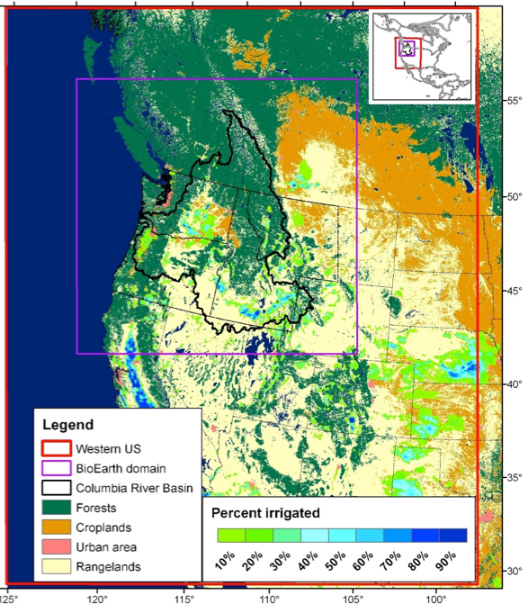
BioEarth DomainThe BioEarth project focuses on the PNW region of the U.S. (Figure 1). As the fourth largest river in North America (as measured by its flow), the Columbia River Basin (CRB) drains complex topography with the Cascade and Rocky Mountain Ranges surrounding coastal areas and the Snake River Plain. The region has extensive and diverse agricultural lands interspersed with heavily populated urban areas and surrounded by pristine natural ecosystems; these lands support a vast array of agricultural and natural resources. Interactions among climate, natural and agricultural resources, and human activities are complex in the PNW. Much of the diversity in resources is due to the large gradient in climate across the basin. Winter-dominated precipitation and cold winters result in a large seasonal storage of water in the snowpack, providing a natural reservoir that supports summer water needs but that is vulnerable to warming (Mote et al. 2003). Storm patterns are closely tied to the jet stream position and sensitive to long-term circulation patterns including the El Niño Southern Oscillation and the Pacific Decadal Oscillation. These climate patterns affect temperature (Mote et al. 2003), precipitation (Wang et al. 2009), ecosystem exchange (Wharton et al. 2009), forest fire regimes (Kitzberger et al. 2007). The PNW is also influenced by long-range import of air pollutants from Asia (Jaffe et al. 1999; Jaffe et al. 2005). Global change is expected to impact natural and agricultural ecosystems through warming, perturbations to precipitation patterns, changes in extreme meteorological events, and increased transport from Asian sources. Concurrent steady increases in human population are applying pressures on environmental quality with continued demand for environmental services. The sum of these effects presents a complex array of uncertainties to public decision-makers struggling to address all of these issues. The diversity of resources and complexity of issues in this region make it an ideal test-bed for the BioEarth model for eventual application over other regions of the world.
Figure 1. Map of the BioEarth domain within the PNW region (purple rectangle) nested within the larger western U.S. domain (red rectangle) for physical atmospheric (WRF model) and land surface (VIC model) processes only. The economic and aquatic model components (streamflow routing, reservoirs, and nutrient export) are implemented only within the CRB (black outline). References
|