The CropSyst and VIC-CropSyst Models
|
CropSyst is a multi-year, multi-crop, daily/hourly time step cropping systems simulation model developed to serve as an analytical tool to study the effects of climate, soils, and management on cropping systems (Stöckle et al., 1994, 2003, 2010). CropSyst simulates soil water budgets, nutrient budgets (N and P), C cycling, crop growth and yield, residue production, soil erosion, and other parameters under user-defined management options (including rotations, tillage, fertilization, and irrigation scheduling and options to deal with water shortages). CropSyst can provide insight into N pollution, GHG emissions, and C sequestration (Badini et al., 2007; Kemanian and Stöckle, 2010; Stöckle et al., 2010).
|

|
Applications to account for climate change and increased atmospheric CO2 concentration impacts on dryland and irrigated crops have been conducted elsewhere (Tubiello et al., 2000; Abraha and Savage, 2006; Rivington et al., 2007; Anwar et al., 2007), and more recently within the CRB (Stöckle et al., 2010).
Development of VIC-CropSyst
The effort to integrate CropSyst into a large-scale hydrologic model began with the purpose of creating a long-term Columbia River surface water supply and demand forecast encompassing municipal, agricultural, hydropower, and ecosystem concerns (Yorgey et al., 2011; Rajagopalan et al., in prep). The integrated model, "VIC-CropSyst", continues to undergo development as a central component of the BioEarth project.
The fully-integrated VIC-CropSyst model allows us to simulate the tightly-coupled dynamics between hydrologic and biogeochemical processes and producer decisions over both irrigated and dryland agricultural regions. Figure 1 demonstrates this model integration, where VIC simulates the hydrologic processes with the exception of transpiration, which is provided by CropSyst. In this implementation, VIC utilizes a large number of finely-spaced soil moisture layers to capture dynamics in the root zone. VIC is modified to simulate crop-specific potential evapotranspiration and to represent irrigation technology-specific evaporation of irrigation water droplets in addition to bare soil and canopy-interception evaporation losses. This allows an improved understanding of the amount of irrigation water that is provided to the crops versus lost through evaporation, surface runoff, or deep drainage. Also simulated by VIC-CropSyst are crop yields, and carbon and nitrogen fluxes.
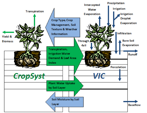
Figure 1. VIC-CropSyst integration details. CropSyst plugs into VIC as a dynamic vegetation and biogeochemistry sub-module, providing to VIC plant water uptake for transpiration by soil layer, water demand for irrigation, and LAI. CropSyst also simulates crop yield and biomass and carbon and nitrogen fluxes (not shown). Note: this schematic was created to emphasize the hydrologic processes that are impacted by crop growth and irrigation, and does not include a variety of other key processes, such as the snowpack, simulated by VIC.
(Figure from Malek et al., 2013, in preparation)
The VIC model was originally developed to couple to regional and global-scale atmospheric models and is therefore rich in its representation of water and energy fluxes and has the flexibility to run at sub-daily time-steps, both of which are necessary for understanding land-atmosphere interactions and for atmospheric coupling. However, like other macroscale land surface models, VIC is coarse in its representation of lateral hydrologic processes. To reduce computation time and avoid breaking model assumptions, grids are necessarily large (107-1010 m2) where sub-grid heterogeneity in land cover, elevation, saturated extent, and a variety of other variables are captured implicitly in space through semi-empirical relationships. While VIC-CropSyst does not resolve individual farms (because these farms are represented implicitly as sub-grid classes within a grid cell; see Figure 2), VIC-CropSyst's strength lies in producing information as to the broader implications of widespread changes in irrigation, fertilization, or crop management decisions.
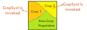
Figure 2. An illustration of how heterogeneity in land cover is handled in VIC-CropSyst. The model is run for each of the "sub-grids" that are associated with each land cover type. These sub-grids are not explicitly located in space but are lumped together as a single unit for each grid cell. CropSyst is invoked only for the sub-grids occupied by cropland. (Figure from Yorgey et al., 2011)
VIC-CropSyst can be applied as a component of more complex integrated modeling platforms. For example, Figure 3 demonstrates how the model is combined with water management models to estimate the impacts of water shortages in irrigated systems. Rajagopalan et al. (2013, in prep) developed this modeling platform for the Columbia River basin (CRB) using the ColSim reservoir model (Hamlet and Lettenmaier, 1999) and spatial datasets of water rights and instream flow target requirements.
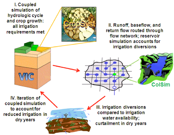
Figure 3. VIC-CropSyst as part of an integrated modeling framework to assess the impacts of water scarcity in irrigated systems.
(Figure from Rajagopalan et al., 2013, in preparation)
Further Information
CropSyst Model Home Page: http://www.bsyse.wsu.edu/CS_Suite/CropSyst/index.html
Technical Documentation on VIC-CropSyst v.1.0: http://www.ecy.wa.gov/programs/wr/cwp/forecast/forecast.html
References:
- Abraha, M.G., Savage, M.J. 2006. Potential impacts of climate change on the grain yield of maize for the midlands of KwaZulu-Natal, South Africa. Agriculture, Ecosystems and Environment 115:150-160.
- Anwar, M.R., O'Leary, G., McNeil, D., Hossain, H., Nelson, R. 2007. Climate change impact on rainfed wheat in south-eastern Australia. Field Crops Research 104:139-147.
- Badini, O., Stöckle, C.O., Jones, J.W., Nelson, R., Kodio, A., Keita, M. 2007. A simulation-based analysis of productivity and soil carbon in response to time-controlled rotational grazing in the West African Sahel region. Agricultural Systems 94:87-96.
- Hamlet, A.F., Lettenmaier, D.P., 1999. Effects of Climate Change on Hydrology and Water Resources in the Columbia River Basin1. JAWRA J. Am. Water Resour. Assoc. 35, 15971623.
- Kemanian, A. R., Stöckle, C.O. 2010. C-Farm: A simple model to evaluate the carbon balance of soil profiles. European Journal of Agronomy 32:22-29.
- Malek, K., C.O. Stöckle, R. Nelson, K. Chinnayakanahalli, J.C. Adam, 2013. Impact of irrigation management on Yakima River Basin's water availability and agricultural productivity using an integrated agricultural-hydrological model (in prep).
- Rajagopalan, K., Chinnayakanahalli, K.J., Malek. K., Nelson, R., Stöckle, R., Brady, M., Dinesh, S.T., Barber, M.E., Yorgey, G., Kruger, C., Hamlet, A., Adam, J. ( to be submitted). "Integrated modeling to assess the impacts of changes in climate and socio-conomics on agriculture in the Columbia River basin. " Water Resources Research.
- Rivington, M., Matthews, K.B., Bellocchi, G., Buchan, K., Stöckle, C.O., Donatelli, M. An integrated assessment approach to conduct analyses of climate change impacts on whole-farm systems. Environmental Modelling and Software 22:202-210.
- Stöckle, C. O., S. Martin and G. S. Campbell. 1994. CropSyst, a cropping systems model: water/nitrogen budgets and crop yield. Agricultural Systems 46:335-359.
- Stöckle, C.O., Donatelli, M., Nelson, R., 2003. CropSyst, a cropping systems simulation model. Eur. J. Agron. 18, 289307.
- Stöckle CO, Nelson RL, Higgins S, Brunner J, Grove G, Boydston R, Whiting,M, Kruger C Assessment of climate change impact on eastern Washington agriculture. Climatic Change, 10.1007/s10584-010-9851-4, 2010.
- Tubiello, F.N., Donatelli, M., Rosenzweig, C, Stöckle, C.O. 2000. Effects of climate change and elevated CO2 on cropping systems: model predictions at two Italian locations. European Journal of Agronomy 13:179-189.
- Yorgey, G.G., K. Rajagopalan, K. Chinnayakanahalli, M.P. Brady, M.E. Barber, R. Nelson, C.S. Stockle, C.E. Kruger, S. Dinesh, K. Malek, J. Yoder, and J.C. Adam, 2011. Columbia River Basin Long-Term Water Supply and Demand Forecast, Washington State Legislative Report.
|
